


Automatic Data and Video Acquisition for uNderwater monitoring across Coastal Environments
JericoNext Advance GallerySummary of the proposal

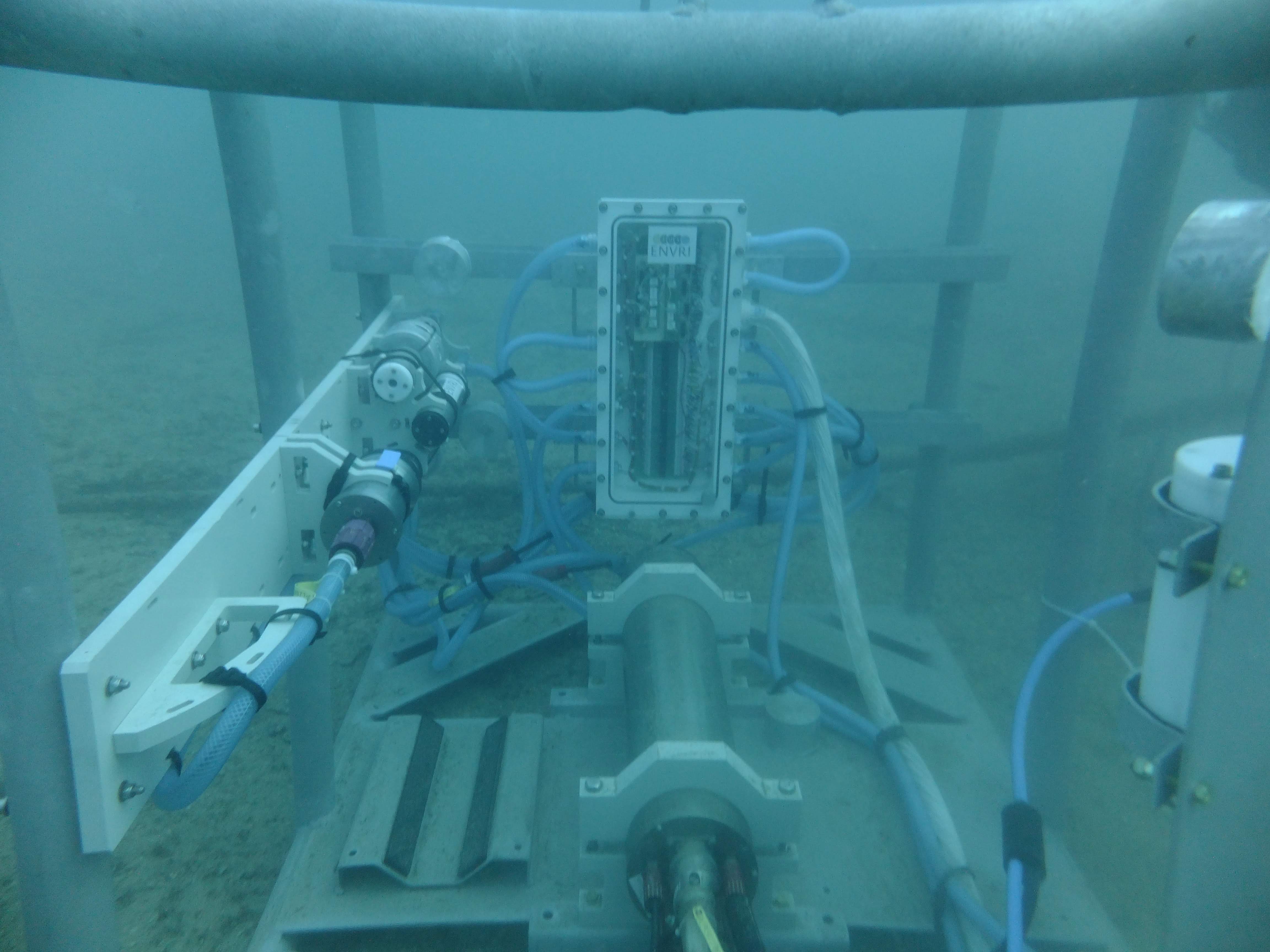
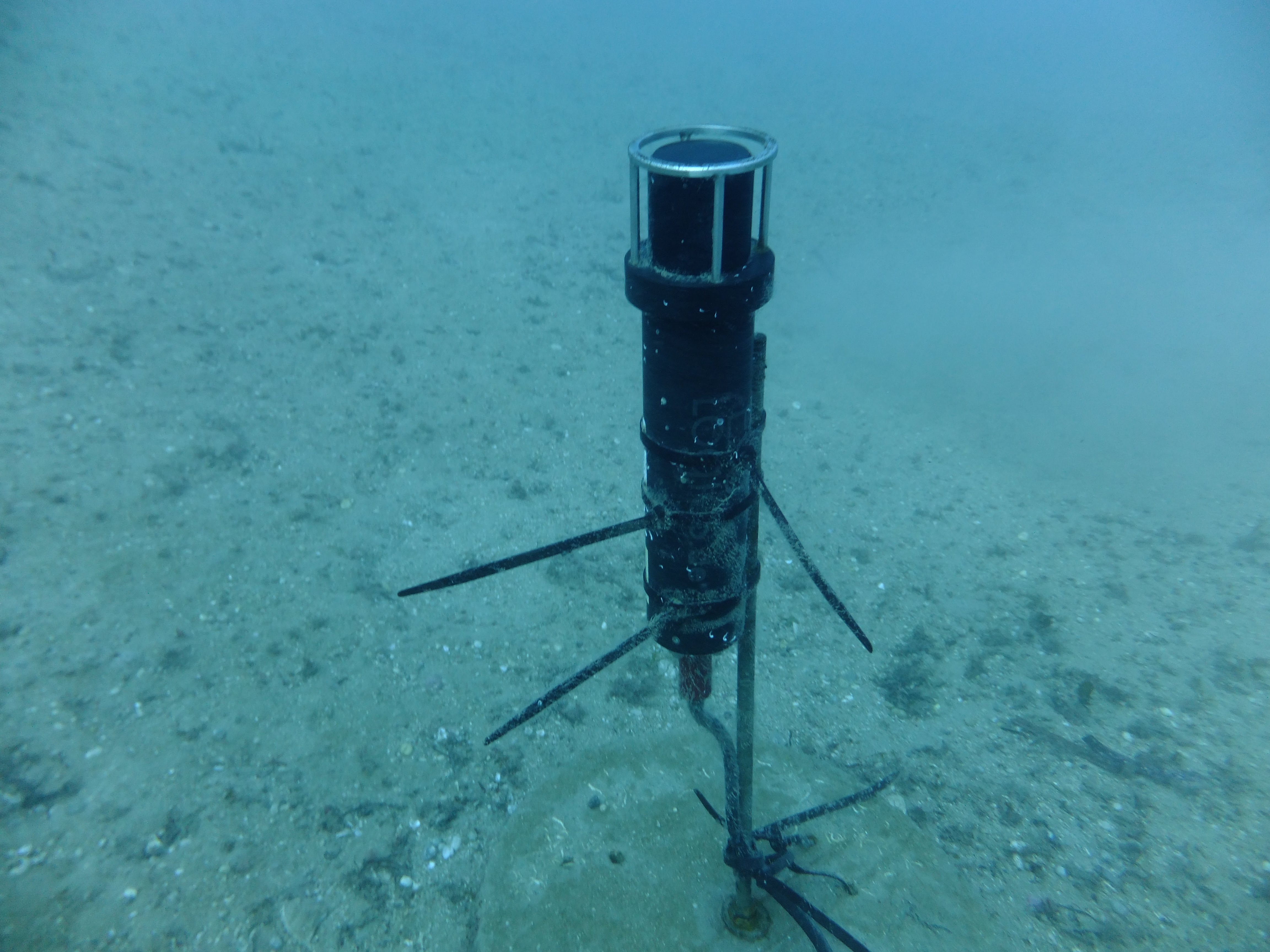
Many devices exist for the acquisition of underwater images. Most of them have been designed to be towed by supporting vessels or to be installed on cabled observatories. These devices transfer the acquired data through cables and the video/image processing is performed outside the acquisition device (e.g. on board the host vessel or at the laboratory); the power needed for their operation, including the lighting system, is assured by cables. On the contrary, very few devices have been designed to be stand-alone (not wired), autonomous (without human interaction) and suitable for working over extended periods of time. In this context, the aim of this proposal is two- fold, technological and ecological at the same time: on one hand we want to test the efficacy of the imaging device GUARD1, described in the European Patent EP2863257 and in Marini et al. (2015) and Corgnati et al. (2016), as a stand-alone and autonomous sensor capable of quantifying biological activities at individual, population, and community levels. The GUARD1 consists of a low- power system conceived for installation on both fixed and mobile platforms for acquiring images of objects or organisms from 1 mm to 100 cm in size. On-board the device, the image content is autonomously analysed, recognized and classified. Even if the GUARD1 is capable to transmit the information extracted from the acquired images outside the device, in this project, such data will be stored in order to be accessed for further analysis after the recovery. On the second hand we will assess the potentiality of this imaging device by comparing the information automatically produced by the system with the visual inspection of the images acquired by the cameras that the two observatories provide. In particular, the images will be acquired continuously during the day and night (by using the GUARD1 lighting system) for a period of at least two months, in order to estimate the image quality with a different diffusion of light and with different conditions of water turbidity.
The biological assessment of the information produced by the GUARD1 will be obtained through the fulfillment of specific data analysis:
- i) achievement of faunistic lists based on image recording: this will be mostly focused on fish but also considering other megafaunal species such as echinoderms, cephalopods or large decapods
- ii) assessment of the minimum number of images required for an efficient sampling of the megafaunal community
- iii) methodological advances for reliable species identification by still imaging sources in the Mediterranean (OBSEA) and in the Atlantic (CPO) coastal areas
- iv) collection of ethological data on species interactions and statistically significant co-occurrences, as a proxy of predator-prey relationships
- v) collection of continuous high-frequency visual data for all detected species as proxy of populations’ activity rhythms at both 24-h and seasonal scale
- vi) linking biotic data on species assemblages with environmental fluctuations (both oceanographic and meteorological).
The project aimed at assessing the innovative imaging technology (GUARD1) for fixed and mobile platforms (Corgnati et al. 2016), as an automatic image acquisition and analysis tool for biological/environmental data acquisition and processing. OBSEA and CPO are ideal facilities where to pursue these goals: they are both located in shallow waters, where the GUARD1 can be easily installed, and they are already equipped with video cameras that can be used for assessing the images acquired by the GUARD1 and for comparisons between different imaging systems
FOULING PROTECTION FOR MARINE OPTICAL SYSTEMS
JericoNext FoulStop GallerySummary of the proposal
Biofilm and Biofouling growth on marine in situ sensors is a well-known bottleneck when autonomous in situ monitoring is performed in seawater. Technological solutions have been under investigations for many years now. Still new improvements are studied.
This project consist to test in the Mediterranean sea environment an innovative technique to protect optical windows that are part of optical oceanographic sensors or more generally part of optical devices like underwater cameras and lights. The biofouling protection is achieved by a conductive layer that coats the optical window and is used to generate very low quantity of hypochlorous acid by controlled in situ chlorination of seawater.
Moreover, this innovative low power demand and very efficient biofouling protection technique can be controlled by a loop system based on a biofilm sensor (Collaboration with ISMAR-CNR,Marco Faimali (Italy) and ALVIM Srl Giovanni Pavanello (Italy)) that can trigger the active biofouling protection device only when biofilm formation is detected. The final purpose of such arrangement is to save energy by controlling the operation of active biofouling protection systems (wipers, bleach, localized chlorination, etc.) and then to lower as much as possible the energy demand and/or biocide release.
Our biofouling protection technology has been fully integrated to TriOS commercial optical sensors and an HD camera. The deployment at sea is performed on an underwater-cabled structure equipped with an EMSO COSTOF II junction box, and an ALVIM biofilm sensor for the antifouling protection control system loop.
arine fouling is very specific to the location where it is considered. The OBSEA Mediterranean location would be very profitable to complete efficiency test of our antifouling system that has been carried out, up to now in Atlantic sea at Ifremer Brest. The OBSEA real time connexion to shore is mandatory to show in real time the performance of the system during the DEMO phase of the EU NEXOS project that is happening at end of 2017. The shallow water of the OBSEA observatory is very adapted to get high fouling development during this period of the year. Finally, the OBSEA observatory is fully compatible with the junction box used on our fouling protection system since the JB is a COSTOF II that is used on the EMSO EGIM module that has been already managed by OBSEA few months earlier.
Long term Underwater localization in extreme conditions
JericoNext Evolul GallerySummary of the proposal
Objectives: Main objectives of the project will be the evaluation of underwater acoustic localization tools deployed in shallow waters. The applications will cover both: static and moving targets. A long term deployment experiment will offer the possibility to ensure robustness of the equipment and quality of the data along time. Variability of the measurements will be studied and correlated with sea conditions since Obsea platform is measuring waves, currents and water properties.
Data acquired by the experiment: Raw data